Hyderabad : 13/07/2021
Hyderabad: Uncontrolled urbanisation triggering more flooding episodes; Study
HYDERABAD: The city has grown 16.5% in the last 20 years, but this rapid urbanisation has resulted in a changed topography that fails to bear the onslaught of even small monsoon rains, causing flooding and misery. A research study, based on satellite data from 2000 to 2020, reveals there was uncontrolled urbanisation, leading to higher flood volumes and more flooding episodes.
The study was conducted by researchers from
National Institute of Technology(
NIT), Warangal, comparing two major episodes of urban flooding — August 2000 and October 2020 — in Hyderabad . The risk between 2000 and 2020 flood events went up by 50%.
According to the study, rapid unplanned urbanization, ignoring the regional and local hydrological landscape has aggravated the flooding severity. “Uncontrolled urbanization (16.5% increase) over the last two decades have substantially influenced the urban hydrology, producing higher flood volumes for comparatively small rainfall event,” the study said, emphasising the need for “regulating urbanization, providing enhanced drain capacity, rejuvenating the water bodies and streams” to check and reduce the spatial flooding extent.
, Tirupati, and
Indian Institute of Remote Sensing, Dehradun, were also part of the study published in the recent issue of ‘Current Science’. The team comprised Vinay Ashok Rangari,
CM Bhattand NV Umamahesh.
Though Hyderabad had not recorded the quantum of rainfall it got in September 1908 resulting in the Musi deluge in the last 113 years, the severity of the flooding has been on the rise. This the researchers attributed to unplanned growth of the city and encroachment of water bodies. “The August
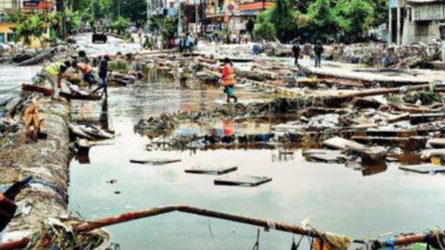
floodsof 2000 (241.5 mm rainfall in 24 hours) caused huge property loss and more than 90 residential colonies were submerged (2 to 4 metres of water level). Hyderabad witnessed another intense downpour on October 13, 2020, and the event points to the persistent warnings that people chose to overlook over these years… the massive flooding… impacted more than 120 colonies, 20,500 homes and causing as many as 80 deaths,” the researchers said.
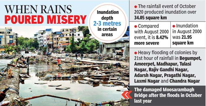
Satellite data showed a significant reduction in open land and an overall decline in the number of water bodies and their spread. The researchers focussed on Zone-12 that comprises Begumpet, Ameerpet, Madhapur, Kukatpally, Rajiv Gandhi Nagar, Chandra Nagar, Tulasi Nagar and Laxmi Nagar. The Zone-12 had 65% impervious area in 2000. It has now increased to 89%. This, in other words, means it witnessed 23.75% concretisation in the last 20 years.
“The increase in imperviousness occurred at the cost of encroachment of vegetative areas, open land parcels and water bodies at 0.95%, 15% and 0.65% respectively. The increased imperviousness limits the infiltration process, thereby increasing the total runoff from the urbanized catchments up to six times and peak flows up to 1.8 to 8 times, thus leading to flooding,” the study said.
The study revealed that in October 2020 rainfall event, water started accumulating at about seven hours of rainfall in the areas along the streamline. The water level started building up with the passing time that caused the spreading of floodwater in adjoining low-lying areas at around 14 hours.
“We can observe a more than 50% rise in high risk for the October 2020 event. Similarly, there is significant rise in low and medium risks compared to the August 2000 event,” the researchers added.
No comments:
Post a Comment